Encountering heterogeneity in the form of stratigraphic layering — interlayering and interfingering of different geologic materials such as sand, silt and clay — is common at every groundwater remediation site where sedimentary aquifers are impacted. Unfortunately, so too is the common practice of oversimplifying the geologic complexity and assuming “layer cake” geology, where it is assumed that the first sand encountered when drilling (often referred to as the “A” sand) is a homogeneous, isotropic layer, followed by the next layer and so on. This almost is never the case in aquifers. Figures 1 and 2 illustrate this concept.
As a result of lateral shifting of river channels over time, the sands in the outcropping cliff face were deposited not from the bottom up as commonly assumed but from left to right as the channel migrated with time. Additionally, the sand bodies are hydraulically separated from one another by thin clay units known as drapes. This shingled, or laterally offset, stacking of sand units is a common feature of sedimentary deposits. The significance of this when addressing remediation of a contaminated aquifer is that water wells installed into the sand for the purpose of monitoring or remediation won’t necessarily be in hydraulic communication with one another — groundwater cannot readily flow between the different units. Such aquifers are termed “heterogeneous and anisotropic,” and recognition of the anisotropy has direct implications on monitoring contaminants, predicting flow directions, modeling the aquifers and remediation. For remediation engineers trying to inject chemicals to break down contaminants or extract groundwater for remediation purposes, the outcome would not be as predicted.
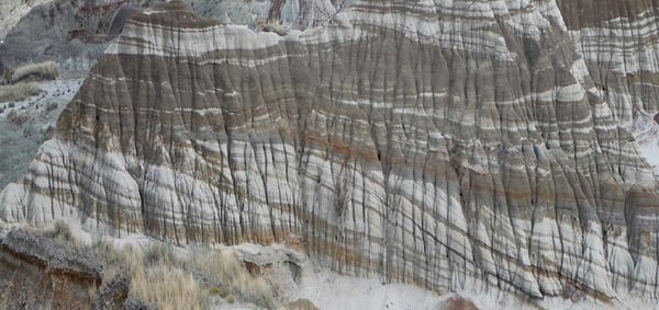
Figure 1: This outcropping of ancient river deposits from the Upper Cretaceous of Alberta, Canada, illustrates the primary challenge of successful groundwater remediation: stratigraphic heterogeneity. In the meandering river deposit, laterally offset stacking of sand units — point bar deposits, pale striations — are separated by clay units, the darker striations.
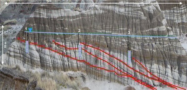
Figure 2: Clay beds dip from upper left to bottom right, depicted by red lines, while blue vertical columns represent three hypothetical well screens. Interwell communication is severely limited because of the stratigraphic dip, showcasing how the hypothetical hydraulic conductivity is orders of magnitude higher than that from the left to right. (Photos courtesy of S. Hubbard, University of Calgary)
High-resolution data acquired via membrane interface probe (MIP) and hydraulic profiling tools (HPTs) are increasingly being used in groundwater characterization and remediation — and this kind of data is extremely useful. However, knowledge of depositional models is still critical to accurately interpret such data. For instance, if the channel deposits, shown in Figure 2, were an actual aquifer, and a transect of high-resolution logs were obtained for characterization purposes, all logs would look quite similar. In addition, homogeneous and isotropic conditions might be incorrectly interpreted based on the data. Lateral shingling could not be identified without knowledge of the depositional environment and stratigraphy, and the important heterogeneity would be overlooked.
Depositional models, also known as facies models — which demonstrate how geological layers are formed — can predict such heterogeneity and should be applied at groundwater remediation sites where sedimentary aquifers are impacted. This is where Environmental Sequence Stratigraphy (ESS) comes into play, delivering significant improvements in efficiency for remediation and monitoring of contaminated groundwater.
As thoroughly outlined in the U.S. Environmental Protection Agency’s Technical Issue Paper on Best Practices for Environmental Site Management, “ESS methodology begins with an understanding of the depositional environment and the use of existing lithology data to elucidate vertical grain size patterns. Work products include geologic cross sections and facies maps that form a basis for integration and interrogation of groundwater chemistry and hydrogeology data.”
ESS, a geologic methodology that is based on the oil and gas industry’s tried-and-true best practice, combines a stratigrapher’s knowledge of geologic rules of thumb with subsurface data to determine contaminant migration pathways and build a reliable, predictive conceptual site model (CSM). A geologically sound CSM, which is the driving force behind every successful groundwater remediation project, incorporates all physical and chemical processes acting within a contaminant plume. Applying the practice of ESS transforms subsurface complexity into an orderly framework that is the basis of improved project analysis and judgement.
Engaging a well-rounded remediation team — armed with an intimate knowledge of the subsurface as well as progressive remediation strategies — is critical to identifying and addressing the complex subsurface heterogeneities that have clear, significant impacts on remedy performance.
Applying the practice of ESS to existing data today saves time and money throughout the project life cycle by guiding the most efficient groundwater remediation solution. In fact, this geology-focused approach helped the Eglin Air Force Base in Okaloosa County, Florida, meet timely remediation performance goals.